
Another Warm November in the Twin Cities
Back to back. November 2015 was warm and wet in an El Nino year and it ended up being the 4th warmest November on record (41.3 F – average is 33.7 F). This November is on track to be the 2nd warmest on record and come in at about a 44 F average temperature (warmest was 2001 with 46.4 F) in what is supposed to be a La Nina winter. This will mean the 5 warmest Novembers on record will have happened since 1999 (in order 2001, 2016, 2009, 1999 and 2015). The last back to back top 15 warm Novembers were in 1922 and 1923 (39.6 and 39.5). November 2011 is also in the top 15 warm Novembers.
Historically speaking the warmest Novembers are followed by about 37.2 inches (about 1.5 feet less than average) and about 3 fewer weeks in the natural snow ski season (which is about 10 weeks).
The warmest November on record, 2001, was followed by 66 inches of snow but it came in spurts and 31.4 inches of it fell after March 14, 2002 and those snowfalls did not last long so there were only about 26 ski days. On the plus side the warm November of 2009 was followed by only 40.7 inches of snow but we could ski from December 9 to March 10 or 92 days. The warm November of 1999 was a La Nina winter, like this winter is supposed to be, and we had 36.2 inches of snow and 55 days of skiing on the natural stuff. Other La Nina winters following a top 15 warm November were 1934 with 51.6 inches and 84 ski days and, more recently, 2011 with 22.3 inches and only 21 ski days. Last year we had 36.7 inches of snow and 51 days of skiing on it.
As a contrast, the 15 coldest Novembers on record average about 56.1 inches of snow and 98 ski days in the following winter. (This does not include 5 cold Novembers in the late 1800s which do not have complete snow records). This includes the top ski day winter of 1950-51 when there was 88.9 inches of snow and 132 ski days. The most recent cold November, 2014, was followed by 32.4 inches of snow and 55 ski days.
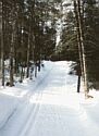
So far we’ve had some snow which is gone here in the Twin Cities area. Fifty plus and thunderstorms on the east side Monday. Normally the snow making operations would be well underway at Elm Creek and Hyland but it has been too warm even at night to make snow and it looks like it will remain that way until the first weekend in December. Remember last year when the short loop was open at Elm Creek but then snow couldn’t be made for a few days due to warm overnight temperatures to complete the manmade loop. Elm Creek has usually been open for skiing during the first week of December but it looks like it will be about 1 week later this year.
A weak La Nina is supposed to kick in and the NOAA climate prediction has a colder than average winter with equal chances (50-50 or about average snow) forecast.
All it takes is a good dump and then some colder temps. We can only hope.